THE LEGACY OF THE PORTLAND DOWNTOWN PLAN
The 1972 Portland Downtown Plan (and its surrounding planning policies) marked a pivotal shift in Portland’s approach to urban development. While it is sometimes colloquially lumped under “housing policy,” it was actually a broader land use and transportation blueprint that redefined how housing, density, and neighborhoods were approached in the decades that followed. Below is a breakdown of its legacy, key features, impact on housing, and how it evolved, along with suggested images to visualize the shift.
Legacy of the 1972 Housing & Urban Development Plan
Official Name: Portland Downtown Plan (1972)
Prepared by: Portland Planning Commission & Bureau of Planning
Context: Post-WWII suburban expansion, urban decay in core areas, national push for freeways and urban renewal.
Key Objectives of the 1972 Plan
Reclaim the Downtown Core
Revitalize downtown Portland as a place to live, work, and shop.
Promote housing in the downtown, which had been hollowed out by commercial use and auto-centric planning.
Shift from car-centric growth to pedestrian-oriented, mixed-use development.
Limit Freeway Expansion
Canceled the Mount Hood Freeway (major freeway that would have cut through SE Portland).
Redirected federal funds toward public transportation (specifically, light rail development).
Preserve Neighborhoods
Created policies that protected older residential neighborhoods (like Ladd’s Addition, Irvington, and Sellwood) from high-density infill or industrial expansion.
Encouraged historic preservation and "neighborhood integrity."
Reintroduce Housing in the Central City
Promoted development of affordable housing and market-rate apartments in the downtown and West End.
Supported conversion of old commercial and industrial buildings into residential lofts and SROs (Single Room Occupancy units).
Public Amenities & Livability
Introduced public spaces like Pioneer Courthouse Square and Tom McCall Waterfront Park.
Encouraged smaller city blocks, active storefronts, and street trees.
Housing-Specific Impacts


Mount Hood Freeway: The Freeway That Never Was
Before (Proposed):
The Mount Hood Freeway was a proposed six-mile expressway intended to run through Southeast Portland. Its construction would have necessitated the demolition of approximately 1,750 homes, significantly altering established neighborhoods.
After (Canceled in 1974):
Due to strong community opposition, the project was canceled. The funds initially allocated for the freeway were redirected to develop the MAX Light Rail system, promoting public transportation over car-centric infrastructure.

Harbor Drive → Tom McCall Waterfront Park
Before (Harbor Drive, 1940s–1974):
Harbor Drive was a major highway running along Portland's waterfront, effectively severing downtown from the Willamette River and prioritizing vehicular traffic over pedestrian access.

After (Waterfront Park, 1978–present):
In a pioneering move, Harbor Drive was removed, and the area was transformed into Tom McCall Waterfront Park. This 36.59-acre green space reconnected the city to the river, offering recreational areas and hosting numerous public events.

South Auditorium Urban Renewal
Before (Pre-1960s):
The South Auditorium district was a vibrant, ethnically diverse neighborhood, home to many Jewish and Italian immigrants. The area featured a mix of residential and commercial buildings with rich cultural significance.

After (Post-Urban Renewal):
Designated as "blighted," the neighborhood underwent significant redevelopment. Many historic structures were demolished, replaced by modernist architecture and public spaces like the Keller Fountain Park, aiming to revitalize the area but also erasing much of its historical character.

Downtown Portland: From Car-Centric to Pedestrian-Friendly
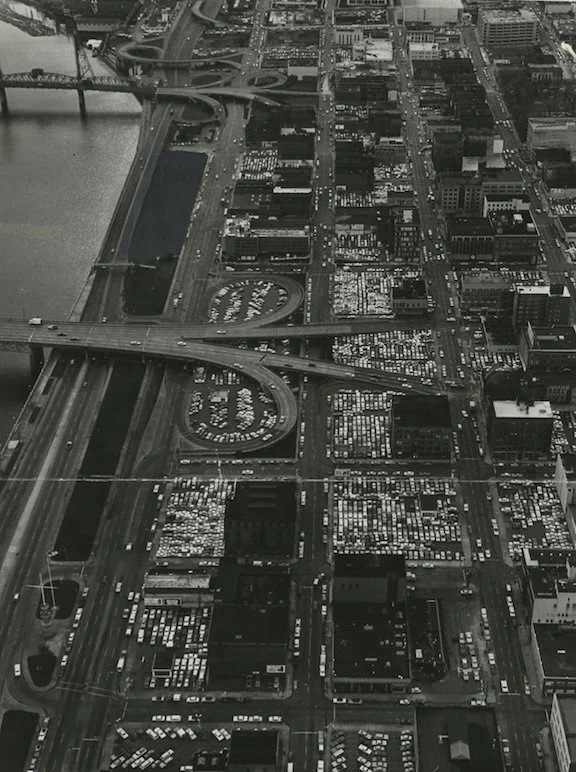
Before (1970s):
Downtown Portland was dominated by surface parking lots and lacked pedestrian infrastructure, reflecting a broader trend of urban decline and car dependency.

After (Post-1972 Plan):
The Downtown Plan initiated a shift towards mixed-use development, improved public transit, and pedestrian-friendly streetscapes. Investments in light rail, bike lanes, and public plazas revitalized the urban core, making it more livable and accessible.
Lasting Legacy
The 1972 plan was visionary in stopping car-centric destruction and reviving the city center, but its preservationist zoning philosophy froze low-density zoning in inner neighborhoods for 50 years.
Today’s zoning reform efforts (like House Bill 2001 and the RIP) are correcting the unintended consequences of those well-meaning preservation goals.